Dubai Metro Map: Your Route Guide
Are you tired of getting lost in the bustling streets of Dubai, desperately seeking the right metro route to your destination? The solution to your navigation woes is here, and it comes in the form of the Dubai Metro Map. In this guide, we’ll tell you all the necessary details about the map of Dubai Metro.
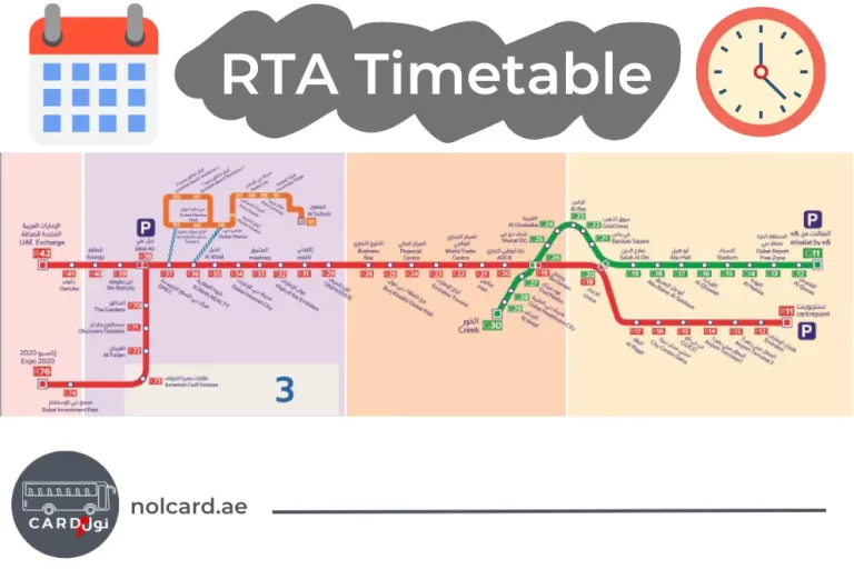
The map outlines all the stations, lines, and interchanges, helping you choose the most convenient route for your destination.
You can find printed copies of the metro map at stations, or you can download digital versions from the official RTA website. The metro map is a valuable resource that ensures you never get lost in the city.
The Red Line
The Red Line of the Dubai Metro runs through seven zones, covering a vast portion of the city. It connects areas like Rashidiya, Deira City Center, Union Station, Burj Khalifa/Dubai Mall, Dubai Internet City, and more.
- R11 – Centrepoint
- R12 – Emirates
- R13 – Airport Terminal 3
- R14 – Airport Terminal 1
- R15 – GGICO
- R16 – City Centre Deira
- R17 – Al Rigga
- R18 – Union
- R19 – Burjuman
- R20 – ADCB
- R21 – Max
- R22 – World Trade Center
- R23 – Emirates Towers
- R24 – Financial Centre
- R25 – Burj Khalifa / Dubai Mall
- R26 – Business Bay
- R29 – ONPASSIVE
- R31 – Equiti
- R32 – Mall of the Emirates
- R33 – Mashreq
- R34 – Dubai Internet City
- R35 – Al Khail
- R36 – Sobha Realty
- R37 – DMCC
- R38 – Jabal Ali
- R39 – Ibn Battuta
- R40 – Energy
- R41 – Danube
- R42 – UAE Exchange
- R70 – The Gardens
- R71 – Discovery Gardens
- R72 – Al Furjan
- R73 – Jumeirah Golf Estates
- R74 – Dubai Investment Park
- R76 – EXPO 2020
The Tram Line
The Green Line covers five zones, primarily focusing on the older parts of Dubai. It connects Jumeirah Beach, Dubai Marina, Palm Jumeirah, and Al Sufouh.
- 01 – Jumeirah Beach Residence 1
- 02 – Jumeirah Beach Residence 2
- 03 – Jumeirah Lakes Towers
- 04 – Dubai Marina Mall
- 05 – Dubai Marina
- 06 – Marina Towers
- 07 – Mina Seyahi
- 08 – Media City
- 09 – Palm Jumeirah
- 10 – Knowledge Village
- 11 – Al Sufouh
The Green Line
The Green Line covers five zones, primarily focusing on the older parts of Dubai. It connects Etisalat, Al Qusais, Union Station, Al Fahidi, and Creek.
- G11 – Etisalat by e&
- G12 – Al Qusais
- G13 – Dubai Airport Free Zone
- G14 – Al Nahda
- G15 – Stadium
- G16 – Al Qiyadah
- G17 – Abu Hail
- G18 – Abu Baker Al Siddique
- G19 – Salah Al Din
- G20 – Union
- G21 – Baniyas Square
- G22 – Gold Souq
- G23 – Al Ras
- G24 – Al Gubaiba
- G25 – Sharaf DG
- G26 – Burjuman
- G27 – Oud Metha
- G28 – Dubai Healthcare City
- G29 – Al Jadaf
- G30 – Creek
If you prefer a visual representation of the Dubai Metro stations, visit RTA’s official website to view the schematic map. It offers a simplified view of the metro lines, stations, and interchanges, making it easier for travelers to plan their routes.
Conclusion
With the Dubai Metro Map 2023 in your hands, you’re now well-prepared to explore the wonders of Dubai. Whether you’re visiting iconic landmarks, discovering hidden gems, or simply commuting to work, the metro system offers convenience, affordability, and efficiency. So, grab your nol card, consult the map, and embark on your Dubai adventures with confidence